

What is land surveying?
If you're buying a property with the intention of developing or significantly renovating it, well you need to know about land surveying.
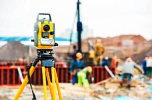
If you're a first-time small developer or renovator, the only time you've probably seen land surveyors is when they're on the side of a road with their special equipment looking at something that you can't see!
 Surveyors work on a diverse variety of projects from planning and design of new or existing infrastructure, land and building development, construction (buildings, roads, bridges, sports fields, farming, etc.), to monitoring and environmental measuring.
They're experts in determining land size and measurements, and give advice and provide information to guide the work of engineers, architects, town planners, geologists and developers.
They also work with all levels of government as well as service authorities such as water, sewer and power authorities.
Surveyors are often the first people on any construction or development site, measuring and mapping the land.
Their measurements are then used by architects to understand and make the most of the landscape when designing, and engineers to plan structures accurately and safely – ensuring buildings not only fit with the landscape but are able to be constructed.
Why do renovators and developers need their land surveyed?
If your structural renovation or development project requires constructing new rooms or additional dwellings after subdividing a block, you need to understand whether it's actually possible, including if it adheres to all town planning codes, and that's why your land needs to be surveyed.
It's also because if you're proposing to build, renovate, develop, subdivide, or change the land use, a planning permit is often required.
These are lodged with the relevant local government department and are assessed against the land zoning, permitted land uses, overlays, municipal strategic statements and various other planning documents.
It's important to understand there are a whole host of different zones that allow for different land uses to be conducted.
There also may be overlays such as wildfire, heritage, vegetation protection on the land as well as particular local provisions such as minimum and maximum land size for subdivision, building heights and plot ratio that you need to know.
What is an Existing Conditions Survey?
So, for structural renovation or development projects, a type of survey may be required, which is called an Existing Conditions Survey.
It also can be known as a site and context plan.
A qualified land surveyor will survey the site to provide information including the location of features such as buildings, vegetation and fences, the slope of the land, building heights, road features and any utility services that are currently present.
 If your project requires a town planning application, the adjoining property buildings are also surveyed including the location of habitable windows, doors, roof ridgelines and eaves.
The land surveyor may also have to carry out a title re-establishment survey to determine the exact location of the property boundaries because sometimes the boundary is different to the existing fence lines.
Of course, this survey is necessary if any of your proposed works are near the boundary.
In areas close to waterways, or in flatter parts of land, the location and heights of drainage and sewer infrastructure is also vitally important.
This information can often determines future dwelling floor levels or the ability of increased density developments to be serviced as existing infrastructure may not have capacity.
What happens to the land survey information?
 By using specialised equipment such as levels, electronic theodolites, tapes and Global Navigation Satellite System (GNSS) units, surveyors can accurately measure land and define boundaries.
Once they have surveyed a property, they draw up a plan for their client and if necessary, they lodge the subdivision plan with Land Victoria or the equivalent State Government department.
The boundaries registered by land surveyors are then recorded in the State's land information system, which includes the boundaries of privately owned and government land, survey plans, survey field records, ownership information, easements and other land information.


Why you must use a licensed surveyor
Licensed surveyors are registered by the Surveyors Registration Board of Victoria (SRBV)
The SRBV is a statutory body responsible for establishing and maintaining the competency and educational standards for licensed surveyors, maintaining a register of licensed surveyors and managing disciplinary procedures.
 A licensed surveyor is the only person legally entitled to undertake a survey to mark the boundaries of your property.
A licensed surveyor will define your land boundaries and upon request should provide a certified plan that confirms the work has been completed correctly.
It's vitally important to understand that surveys prepared by non-licensed surveyors do not have legal standing and will not be recognised as evidence in the event of a boundary dispute.
It's not worth the risk, so make sure you only use a licensed professional to survey your land.
Non-licensed surveyors are able to carry out many other forms of surveying including Existing Conditions Surveys, engineering, construction, environmental and monitoring surveys.
How much does land surveying cost?
Fees for land surveying can range anywhere from $500 to tens of thousands of dollars depending on the scope of works required.
When calculating the total surveying costs, a number of factors have to be considered including:
 Site location — The area where the property is located directly affects the price. You may be charged a higher rate if there are plenty of trees present or if the property is not easily accessible to vehicles.
- Size of the property — The larger the property, the longer it will take to survey the land.
- Shape of the property — It is cheaper to have a rectangular-sized property measured and surveyed compared to a piece of land with irregular borders.
- Physical features of the land — You may be charged higher surveying rates for properties located in a mountainous terrain with plenty of foliage. Apart from the difficulty of surveying these lands, they’re not easily accessible as well.
Given a structural renovation or development costs tens or hundreds of thousands of dollars, the cost of having the land professionally surveyed is small change in comparison to the total project cost, isn't it?
Set out Surveys for construction, engineering, and development
Often when any new, improved, or upgraded development (building, road, oval, bridge etc.) is to be constructed, the exact locations of these works are required to be set out by a surveyor.
 They can be as simple as setting out a reference line to allow builders to position the building but often these days with the increase in technology allowing for more detailed and intricately shaped buildings (often constructed off-site), the need for precise set out is invaluable.
On a sloped site, our equipment can measure horizontal distances which often causes headaches for builders as they usually haven’t got the equipment to measure the horizontal distance and requires step chaining which reduces accuracies as you go.
With the correct setup, our equipment can measure these distances to within a few millimetres.
We can also measure vertical distances which are invaluable in providing for cut and fill measurements when constructing a road, drain, or for setting out an excavation for a pipeline.
 Having the right set out data at the outset is so important as it provides surety to the construction teams, reduces time loss, and allows those on site to do what they are experts in.
What we do at Step Surveying is interrogate the design plans and create our own ‘shop’ plans that have all information required for the set-out.
We work with all involved to determine what set out information is required so that we have a plan of attack prior to a site visit.
We are there to help not hinder the construction works so we are always thinking of ways to help out and minimise site delays.
When the set out is complete we make sure that a site handover is carried out, and we provide set out plans for reference usually by the next day.
We are also very responsive to set out requests — often available the next day so please contact us today to discuss your project.


